Posts Tagged ‘mosquitoes’

Saturday, July 10, 2010 Return Creek Miles Today: 24.2 Total: 965.8

Saturday, July 10th, 2010

july10_6bridge

I never thought I’d be able to get up at 5am and start hiking, because I was so exhausted from yesterday, but the realization that “I can get rid of the bear can at Echo Lake!” was a HUGE motivator!  The sky was full of little puffy clouds, moving fast.  “I wonder what kind of weather we’re in for today?”  I wondered.  It wasn’t a cold morning–only 50 degrees, which is “warm” for this altitude!

I love walking the PCT around Tuolemne Meadows, because my family used to camp, fish and walk here for a week every August. As we followed the trail through the meadows, across some more creeks, and over the vast sheets of glistening granite, I enjoyed the views of what I call “the Tuolemne Meadows icons” like Lembert Dome, Cathedral Peak, etc.  The farther we got from Tioga Pass, though, the worse the mosquitoes got, till we had to put on our headnets just to hike in peace.

july10_9mountains

We reached the bridge over the Tuolemne River, where the placid waters start their whitewater plunge steeply down into the Grand Canyon of the Tuolemne.  Several hikers were lounging at the bridge, and as we began the descent into the Canyon, we met quite a few more.  They were all so clean!  I’m afraid at this point on the PCT, our own clothes look pretty grungy, even though we wash them every time we’re at a resupply.  All the hikers were “heading home” from overnight camping at Glen Aulin.

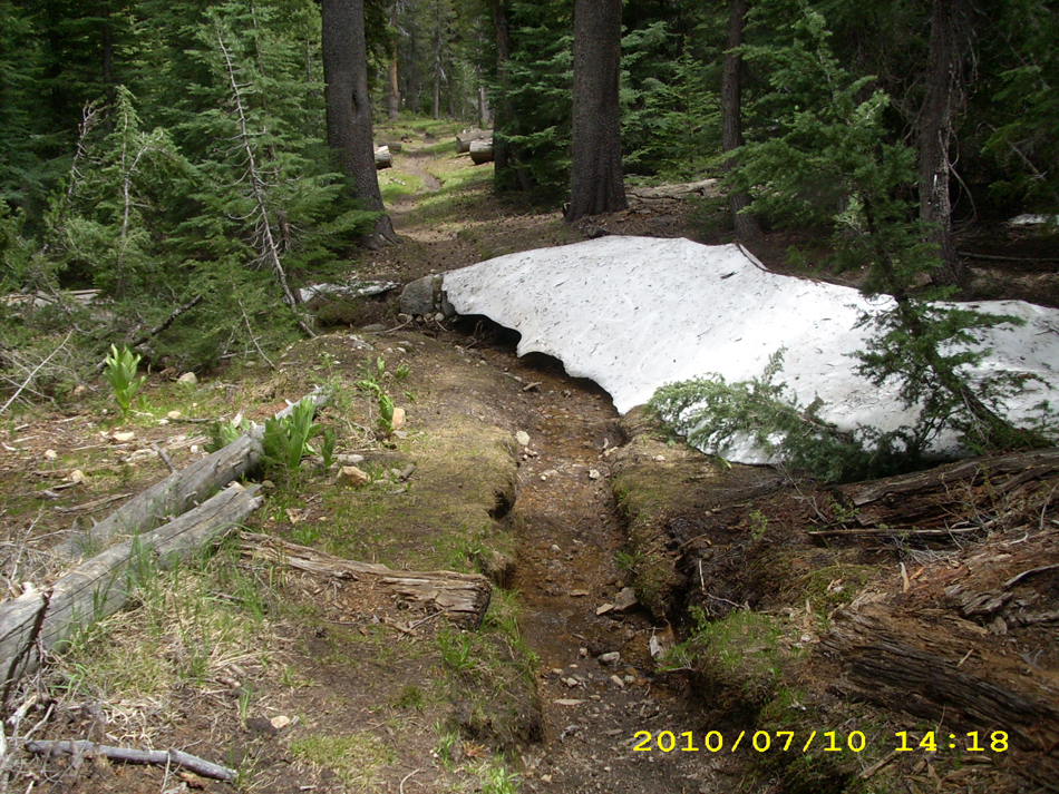
The PCT turned off and began to climb up along Cold Canyon creek.  The trail was actually DRY!  Wowee!  No mud!  We were making good time, but I was dreading the crossing of Return Creek, a notoriously “dangerous” ford up ahead.  Along the way, we caught up with a sweet old guy out backpacking with a TON of photographic equipment.  He was very cheerful about the weight he was carrying.  I was impressed!  We stopped for lunch just before Return Creek.  A little bit more hiking, and we could hear the roar of Return Creek just ahead.  I was praying silently, “Please, Lord, help me get across OK”.  Well, not to worry!  One look at it, and I said, “Bear Creek was a lot worse! I  can cross this, no problem!”  So I crossed Return all by myself, and cheered when I made i to the other side!

 A long uphill climb through slowly increasing patchy snow and several more creek crossings brought us to pretty Miller Lake with a sandy beach. Nice! A bit more up, and we were at the spectacular dropoff of Matterhorn Canyon. To me the Canyon looks like scaled-down Yosemite Valley.  Beautiful!

july10_11traillake

A lot of switchbacks (and snow travel too) and we were at the canyon bottom. It’s a nice long walk along the valley floor, with plenty of time to savor the spectacular views, and plenty of tributary creek crossings. Oh, for just one day of dry shoes, socks and pants!

After eating supper with a lovely view of Matterhorn Creek and the canyon, we tackled the long climb up to Benson Pass.  The PCT follows a very pretty, cascading creek lined with green grass and wildflowers.   The trail tread crisscrosses the creek several times, and we ended up camping just before the last ford of the creek, where the PCT turns for its final climb up to Benson Pass.  There were plenty of mosquitoes around, but we were too tired to do anything but toss down a groundsheet, our sleeping pads and sleeping bags and then collapse.   I wore my hat and mosquito headnet to bed, hoping that would more or less protect me from those “mossies!”   But what a relief to know that Return Creek is behind us!  I know there are more big creek crossings ahead, but Return is the one I dreaded the most.

Walk to Rauros: Bare winter trees on both sides of river

july10_1lakejuly10_2mountainjuly10_3mountainjuly10_4lakejuly10_5crossingjuly10_7trailviewjuly10_8waterfalljuly10_10trailforestjuly10_12viewlakejuly10_13viewtrailjuly10_14viewmountainjuly10_1sunrisejuly10_2sunrisejuly10_4montymeadowjuly10_5lakejuly10_6baretrailjuly10_7roaringwaterjuly10_8trailmeadowjuly10_9creekmonty

Friday, July 9 Tuolemne Meadows Miles today: 20.6 Total: 941.6

Friday, July 9th, 2010

july9_2mntlake

The 20+ miles we did today were tough miles, but we managed to land up in the end at Tuolumne Meadows! We were up ‘n at em at 5:00am, knowing we had TWO snowy passes to cross. First was Island Pass, with its gorgeous views of Banner Peak and Thousand Island Lake. The snow was definitely a factor, but not too bad compared to what we have been through. We never lost the trail for very long.

Then the PCT took us down into an area with a multibranched creek, and we got totally messed up. Wel missed a turn of the official PCT, and unknowingly headed off on some other trail that eventually just petered out in the woods.  We tried to go back and find the PCT again, which involved a lot of creek crossings, and no luck in locating any trail.  Bill finally said, “Forget this!  Let’s just go for it.  We’ll go straight up and get to Donohue Pass somehow.”  So we just headed off through the woods and uphill.  Eventually we came to a very rocky area, and oh joy!   There was the trail again!   (I think Bill may have been a little disappointed, though.  He sort of likes bushwhacking adventures!) 

The rest of the climb up to Donohue Pass was a rerun of what we’d been through before–watching for bits of trail appearing out of the snow, and heading for them.  When in doubt, oh well–just head for the top of the pass.  One really nice thing was that Donohue is not a steep, scary pass like some of the others, and it isn’t rough and rocky.  Instead, it’s huge sheets of smooth granite–very comfortable to walk on.   When we reached the top, we were very amused by a drop box where people could leave their survey forms (not sure where they got them originally) to give their opinion about their trail experience.

july9_6snowtrail

As we started down the other side of Donohue, we began to meet more and more JMT’ers–all sorts of folks, both old and young.  Partway down we stopped to cook a hot lunch, but didn’t linger over it, because we were determined to reach Tuolemne Meadows post office before it closed. So once we were across the last “big ford” of the Tuolumne River, Bill took off. I followed as fast as I could.  The trail was very rocky and rough as it headed down into the Tuolemne River valley–which made for slow going (for me), but the flowers (especially the “heather” ) and the views were so beautiful!   Whenever I am anywhere near Tuolemne, I alwasys feel as if I’m “coming home” because my family camped here several times when I was a kid.

Once I made it down the rocky hill, the PCT goes for many miles through green meadows, forests,  and creek crossings.  I very much wished it were earlier in the day so that I could linger and walk more slowly to enjoy the beauty,  but instead I pushed along as hard as I could.  A couple of miles before I reached the campground, I was so exhausted that I had to slow down, and by the time I reached the “hiker hangout” by the store, I was totally wasted.  All I could do was just collapse on the ground.  It was 6:15 pm, and it turned out that Bill had only beat me by 40 minutes. 

 However, he did have our box, and he had bought some Odwallas,  so I lay on the ground and slowly sipped an Odwalla till I felt revived enough to tackle sorting the box.   Lots of other thruhikers were doing the same thing–it was fun talking with everybody and seeing what they had in their boxes!  The Disraeli Gear had really interesting stuff–they are from Israel, and their food items were not like ours.  I particularly enjoyed talking to “DoubleCheck”–he’s a very enthusiastic, interesting chap.  Meanwhile, Bill had gone off to find us a place to camp.  His final conclusion was “Let’s just go to the backpacker camp.” 

So with heavy packs (7 days of food to get us to Echo Lake), we strolled over to the backpacker zone.  I was concerned about finding a water faucet where we could fill our platypuses.  I asked several people, but nobody knew anything.  All they could say was, “I guess you could get water at the bathroom.”  At this point, I was so tired that all I wanted to do was collapse, but instead I ended up wandering all over the campground, looking for a faucet.  No luck.  I couldn’t believe it!   Finally, almost ready to cry, I dragged myself back to our camp and voila!   Not too far away, near the campfire circle, I found the faucet!  As soon as I filled the platypuses, I crawled into my sleeping bag, completely wasted.  Bill and I are cowboy camped, and surrounded by lots of JMT’ers in big tents.  I couldn’t believe they were planning to drag those big heavy tents with them!  And they were equally astounded that we only carry a tarp, and only set it up if we HAVE to.

The ranger campfire program nearby was a familiar sound, and it was nice to know that our food was safe in a bear box for the night.   All through the Sierras, Bill and I have been keeping only our “smellier” food in the bear cans (things like Snickers and cheese, etc).  The rest of our food just parks in the food bags as usual, and we sleep with the bags right next to us and trek poles at the ready in case a bear comes around.  We’ve never had a problem, since we never camp near water, nor do we camp where other hikers are.  But still….it was a good feeling to have that nice bear box!   And it is so wonderful to have reached Tuolemne!

Walk to Rauros: Leave the border of Lothlórien and are given gifts from Galadriel

july9_1sunrisemntjuly9_3billmntjuly9_4mntcreekjuly9_5trailrocksjuly9_7signjuly9_8snowmntjuly9_9greenhillsjuly9_10meadowcreekjuly9_11creekjuly9_12hikerstablejuly9_1sunrisejuly9_3snowfieldjuly9_4snowviewjuly9_5snowmountain

Friday, June 25 Miles today: 24.3 Total: 736

Friday, June 25th, 2010

25june1viewdark

A lot of clouds came in last night and before we’d finished breaking camp at 5:00 am, they started dripping. ( Nothing serious, as it turned out).  A minute’s walk took us to the edge of the Beck Meadow branch of Monache Meadows.  It’s an awesome sight–a vast green meadow with white Sierra peaks on the horizon.  As we entered it, the “bit of drip” from the clouds turned into hail!  I had my umbrella up, so just stepped under a tree to wait and see if the hail would become a problem (it didn’t), but poor Bill had stuffed his raingear way down at the bottom of his pack (he didn’t consider the bit of drippiness to be worth putting on a rainjacket) and it was a major project for him to rummage everything out, find the raingear and put it on, then repack.  By the time he was done, it had pretty much stopped raining!  

Our first goal was  “breakfast at the swallow bridge!”  so we chugged right along up and down through the woods, till we were out in the meadow again and could see the Kern River down below.  As I expected, when we got to the bridge, there were lots of thruhiker tents!  Camping by the bridge is not a bad idea, because so many swallows means there are NO mosquitoes!  We could eat our breakfast in peace and watch the swallows feeding their babies who were tucked in nests under the bridge.  Most of the other hikers were just starting to get up. 

25june4bridge

The PCT took us out across sagebrushed meadows (no cows this time–we did see plenty of cows in 2005).  Huge yellow primrose-type flowers were blooming  along the trail.  We headed up Cow Canyon, where we got lost in 2005 because the cow trails and the PCT looked so much alike.  No problem this time–the PCT route was very distinct.  It does crisscross Cow Creek several times, and that was part of what confused us in 2005.   The creek was running well and was very pretty.  But oh, man, it’s a long, long climb, all the way up to 10,500 feet.  Our packs are so heavy that we had to stop and rest more often than usual.

Finally we reached the big downhill to Gomez Meadow.  The mountains here are very rocky and have many dramatic cliff formations  that look sort of like a mini-Yosemite.  We’d planned to get water at Gomez Creek, but oh bummer–it wasn’t a creek, it was a marsh, and the water looked gross.  We sighed and pushed on to Death Canyon Creek, which turned out to be a gorgeous place! Not only is the creek clean, but there’s even a “swimming hole” (well, bathtub size, actually) right near the PCT.  If it were a warm day, we would have jumped right in, clothes and all, but today has been cloudy, windy and chilly.   We settled for taking a nice Snickers break instead, and we took on 3 liters of water each–we were worried about dehydrating at this higher altitude.  I groaned when I put my pack back on and faced the killer climb out of Death Canyon, back up to 10,700 feet.

25june11rocks

But even though the climb was hard, it was worth the effort!  The rock formations along the trail grow more and more impressive, and the trees look like enormous bonsais with reddish-brown bark.   Views at the top are unbelievable— thousands of feet down to the Owens Valley. We had to hike “overtime”— past 7:00pm— along the steep mountainsides before we could reach a saddle with flat places to camp.

 The mosquitoes were waiting for us, and the clouds looked a bit threatening, so we rigged both tarp and net tent.  It’s a nice quiet forest here, out of the wind, and not too chilly.  It felt great to be inside away from the mosquitoes, but I thought about the snow patches we’d started seeing by the trail and wondered what it would be like in lots of snow.  Tomorrow we also face our first “snowmelt creek” crossing at Rock Creek.  It will be my first High Sierra early season creek crossing, and I am a bit worried about it.  Boy does it feel good to be horizontal!  Bill and I are both totally tired out.

Walk to Lórien: Climbing up base of Redhorn

25june2viewdark25june3bridge25june5flowers25june6trail25june7view25june8view25june9trail25june12trail25june10mountain25june13rocks25june15vista