Sunday, May 15 Start Ley, Finish Bear
Sunday, May 15th, 2016
 SUMMARY: One thing about the CDT–to get from Point A to Point B, you often have several choices of which way to go, and those choices can overlap. Today we began on the “Ley Red Route” from Hwy 12 to Pie Town, but finished the day on a different route–the “Bear Survey”. This change was accidental–the two routes came together for awhile, and we went with “Bear” even though we didn’t mean to. This happened way up high on Mangas Mountain, with fantastic views for miles around, and lots of trees (aspens, too!) and wildflowers. Tonight we are cowboy camping down at the base of Chavez Canyon. Pie Town tomorrow!!
DETAILS: It pitterpattered rain much of the night last night and this morning when we started hiking, the trail was covered with raindrop prints, while everything else was still dry as a bone. At 6:45 am, when we reached Hwy. 12 (where you can hitch into Reserve, NM), we found a little note/ad “We’ll come get you; Resupply; Rooms” We were filthy dirty, tired, and hungry, but with Pie Town only 2 days away, we kept on going.
As we were hiking, I was trying hard not to worry about losing the trail again today. Man, do I miss the PCT! It was such a friendly and welcoming trail that it soon felt like home. The CDT is like a lurking enemy waiting to trip you up. But I have learned one thing so far: if we stay with the Bear Creek Survey route, there’s a much better chance there will be rock cairns or blazes or something to show which way to go. If you choose a Ley Red Route instead–all I can say is “Have fun! Good luck–you’ll need it!” The problem is, the Ley Red Routes are often much shorter or more sensible, so despite the difficulties, we often “go Ley” anyway.
After Hwy. 12, we arrived at a magnificent “CDT gateway”. Very impressive! There were horse corrals, signs with maps, and nice trail. The only problem was, we only wanted to do the official CDT for about .4 mile, and then switch to the Ley Red Route. I was concerned about locating the point where we would make the switch, but when we got there, no problema! Somebody had scratched in the dirt a very large “L R”, with an arrow pointing right. (“LR” = Ley Route) After so much time being lost, I watched the trail (well, forest service roads, really) and maps very closely. It took us through a variety of forest and pastures.
The CDT here is giving us a great sampling of New Mexico ranchland. There are cows & calves everywhere. We’ve crossed lots of cattleguards, gone through all kinds of gates, crawled under barbed wire so many times that I’ve lost count, while at the same time we’ve been enjoying the incredible blue sky, white clouds, golden pastures, and wide variety of trees and wildflowers. There is a distinct difference in the kind of trees, depending on your elevation. Again I wish we weren’t trying to beat the snow to reach Canada, because I would love to stop and just enjoy all this for awhile.
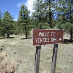
By noon, we’d reached a very nice campground, and we got to sit at a TABLE to eat! But there was no water, and our water is pretty low. If we severely ration, we might be able to make it to Pie Town. Maybe. Our maps showed the possibility of a spring (named “Tio Vences Spring”) not too far from the campground, up a side road off the CDT. When we got there, at first glance there was no sign of water. But there was a barbed wire fence around some decrepit looking concrete boxes, worn out hoses and broken faucets. Fixit crawled under the barbed wire to have a look, and came back very happy. “Water!” he said. “But it will be hard to get at. I’ll have to rig some way to reach down into the box.”
So we took ALL our remaining water, added electrolytes and just blew it down. Man, it was good to be able to drink our fill! Then Fixit took some string and 2 trek poles and a water bottle and rigged them all together to reach the water. While he was doing that, I set up our “AquaMira kitchen” to “cook” some AquaMira, ready to treat the water he was pulling out of the box. This is the system we’ve figured out in order to save a bit of time: Fixit gets the water, while I set up the AquaMira in a collection of bottle caps. It takes 5 minutes to “cook” AquaMira before putting it in the water. We both took on 4 liters of water, which is the most we can COMFORTABLY carry.
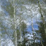
At this point, we started the big climb up Mangas Mountain. The views became more and more amazing, and soon we were up in what felt like “high mountain” air, with high mountain trees. Even though it was mid-May, the aspens were barely even beginning to leaf out. And it just felt more like “home” back in the Sierras of California. I was really enjoying myself! We have plenty of water now, it’s beautiful–what more could we want? But up close to the top of the mountain, we lost our way again. Sigh. We thought we were following the Ley Red Route, but when the trail and the map started to disagree, we realized, “Oh no! We’ve wandered off onto the Bear Route!” Ley’s Route went east, and here we were going north instead. (The direct reverse of the time we messed up at Sapillo Creek!)
We debated what to do, and since we’d come DOWN quite a ways, we decided it was not worth climbing all the way back up the mountain again, just to find Ley’s route. So Bear it was. Oh well, it means a road walk to Pie Town, but that’s OK. (With Ley, we could have avoided the road walk). We are both so dirty (all that crawling under fences) and so tired and so hungry, but we’ll make up for that at Pie Town tomorow!
Once we were down off the mountain, we stopped to camp at the base of Chavez Canyon, near a “cow tank” (artificial pond). The water in the tank was totally disgusting. So glad we didn’t have to get water there! Today was a great example of the multiplicity of choices we hikers have on the CDT, but I do wish our Guthook was working so we’d be able to do a better job of choosing which way to go!