May 21, Sat.–11.1 miles–So. CA B
Saturday, May 21st, 2005
Sat. May 21 PCT miles today: 11. 1 + 8 mile roadwalk + about 6 miles Total PCT so far: 198.3 miles
We were so tired that we “slept in” this morning till 5:15! At the foot of Black Mountain Road, which leads up to the PCT, we passed by Brian still zonked in his tent. Hope he had fun climbing Tahquitz Peak today! For us, first it was 8 miles of walking up a dirt road to get back to the PCT. We could see Fuller Ridge, and yes indeed, it looked “full” of snow. Without GPS, there is no way we could have made it. About 3 miles up the road, we were passed by a couple of truckloads of smokejumpers, presumably headed for the fire lookout tower. They looked like tough but cheerful guys.

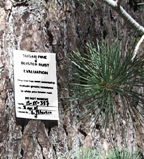
A genetically tough pine tree
We also noticed that several of the pine trees near the road had little white cards on them which basically said, “Don’t cut this one down–we’re using it for a study in genetic resistance to white pine blister rust.” No kidding! The “carded” trees were green and thriving–the others looked sick.

Awesome and awesomer views!
As we climbed higher, the views grew amazing-er. (Guess I sound like a broken record on that, but seriously, one of the most fantastic things about the PCT area is the incredible views you get!) We could see Mt. Gorgonio in snowy splendor just across the hot desert valley we must cross tomorrow.
Finally we got back to the PCT–a VERY welcome sight! But we really wanted to see if we could get at least a LOOK at the Fuller Ridge part of the trail, so we hung our food, hid our packs, grabbed lunch and ice axes, and headed “backwards” on the PCT.

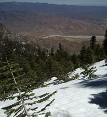
Standing in snow, looking down at desert below
But doggone it–the snowdrifts all over the trail got worse and worse. Many were taller than I am (climbing over them was interesting!) and all were on steep hillsides. It was weird to be ice-axing our way through snow, while just below, the desert baked with heat. But finally, after only 1 1/2 tough miles, we had to give up. We just could not figure out WHERE the trail went.

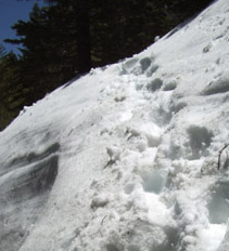
Our footprints going over huge snowdrift
So we followed our own footsteps back, a little easier because the snow was softer and we didn’t need ice axes as much. But by the time we reached dirt trail again, I was so wiped out from all the slipping and sliding and chopping steps that I just lay down flat and didn’t move for awhile!
But now we needed to think about our water supply. We had 15 miles of downhill-to-the-desert ahead of us, and no water on the trail. The nearest water was at a creek, 1 1/2 miles back down the road. So off we went with our platypuses, and filled them from the creek. Snowmelt water–COLD! GOOD! Then we soaked our tired feet in the creek, too. Too bad for the people downstream–our feet were pretty stinky! (But carrying fully loaded heavy platypuses back to the PCT was a bit of a slog.)
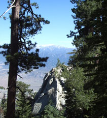
We located our packs and food, loaded up, and headed down the trail, at first through forest. So few people have done this part of the PCT this year, that the trail was pretty messy with fallen branches, sticks, etc. But we persevered, and got plenty of miles in before dark, including a great view of Mt. San Jacinto. We also got to navigate around an amazing ridge of what the guidebook called “granito-diorite nedles”. But with the sun going down, it was time to find a flat place o sleep and call it a day. Tonight we’re being serenaded by the sound of freight trains in the valley below, plus (sigh) the whine of mosquitoes. They are everywhere! We should have carried our net tent all the way from Campo! But it is a beautiful night, and we are very glad to be back “home” on the PCT!

